


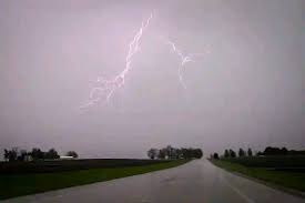
Mbabane – The weather might change before the day ends as severe thunderstorms with hail, strong winds and localised flooding are expected across Eswatini, the Eswatini Meteorological Service has warned.
The alert is in effect from 1400hrs to 2359hrs this Tuesday, and the public is urged to take precautions as conditions may become hazardous.
The Eswatini Meteorological Service advises residents particularly those in flood-prone or hail-prone areas to stay alert, avoid crossing flooded low-water bridges, secure loose items and follow official weather updates throughout the day.
In its evening update issued on Monday, the department reported a few thunderstorms and rain in some areas overnight, with cloudy and cold conditions before skies became partly cloudy. However, forecasters say more intense and potentially dangerous weather activity is expected this afternoon and evening.


Today’s outlook shows morning fog in some places, followed by partly cloudy and warm conditions, becoming hot in the Lowveld. Isolated thunderstorms and scattered rain showers are expected throughout the day, with severe storms most likely later in the afternoon.


Winds will be light to moderate northerly, becoming south-easterly as the day progresses.
Forecast temperatures for today are as follows:
- Mbabane/Nhlangano/Pigg’s Peak: 14/26°C
- Hlatsi: 13/25°C
- Mankayane: 15/27°C
- Manzini: 17/29°CSiteki/Lomahasha: 16/28°CBuhleni/
- Mayiwane: 17/30°C
- Mhlume/Simunye: 18/31°C
- Big Bend/Lavumisa: 19/32°C


Discussion about this post